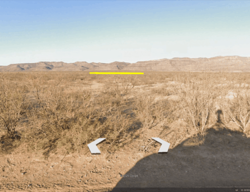
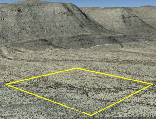
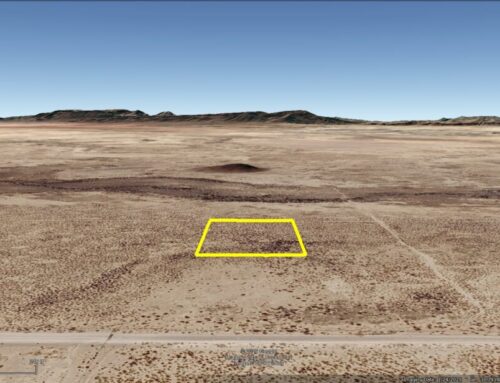
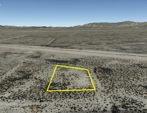
20 Acres in Pecos County near Highway 285 and the Reeves County Line. Located about halfway between Fort Stockton and Pecos,TX. As always, no credit-check needed, zero percent interest financing and no pre-payment penalties. Everyone Qualifies, just pay the doc fee/down payment and sign the contract online.
This property and all of the neighboring properties have 20 foot access easements along the property boundaries.
Cash Price: $21,400
Owner Finance: $22,400 – $300 doc fee/$0 down & 112 payments of $216.97 ($200 Loan Payment, $10.00 Service Fee, $6.97 property tax)
• No credit check
• No interest
• No prepayment penalties
Click Here To Pay Your $300 Doc Fee
Note: Down Payment & Doc Fee can be paid using credit or debit card. Monthly payments must be paid using ACH – checking account/routing number.
Property can not be used to raise animals or as a primary residence while making payments on the property.
⚠️ Important: While you can camp and enjoy your property while making payments, permanent residency is not permitted until the land is fully paid off. Weekend camping and recreational use are welcome!
Acres: 20
Property Id: 31670 & 31517
Legal Description:
5533 49-8 T&P Sec 22 SW 1/4 SE 1/4 NW 1/4 TR 15 BLK A, 10.180 Acres.
There is to be a 20 ft easement on the north, south, east and west boundary of above said parcel for access and roadway purposes.
5533 49-8 T&P Sec 22 SE 1/4 SW 1/4 NW 1/4 TR 16 BLK A, 10.180 Acres.
There is to be a 20 ft easement on the north, south, east and west boundary of above said parcel for access and roadway purposes.
Pecos CAD: https://pecoscad.org/Home/Details?parcelId=31670 & https://pecoscad.org/Home/Details?parcelId=31517
Pecos County Tax Office: https://www.pecostax.org/Home/Details?parcelId=31670 & https://www.pecostax.org/Home/Details?parcelId=31517
Pecos CAD GIS Map: https://maps.pandai.com/PecosCAD/?find=31670 & https://maps.pandai.com/PecosCAD/?find=31517
Recorded Deed: recorded purchase deed 20 Acres PECOS 31670 & 31517
Previous Owner’s Recorded Deed: deed copy Torres 20 Acres PECOS 31670 & 31517
Elevation: 2,736 ft.
Topography: Flat
Roads: Dirt
This is off-grid land. There are no city utilities here. You can use batteries, a generator, solar panels, or windmills for electricity.
For water, you can bring it with you, drill a well, have water trucked in and delivered, set up a rain catchment system
State: Texas
County: Pecos
Property Tax: $83.63
Nearest Town: Fort Stockton City
Have Questions? – Read our F.A.Q.s or send us a message or see our testimonials.
Google Map Link: https://maps.app.goo.gl/dcL5YQDGPCLByhNq9
A phone app such as Land Glide or OnX Hunt can be used to find parcel lines and corners while walking the property (if using OnX Hunt be sure to add the “TX Private Lands” map layer to see the parcel lines).
GPS Coordinates:
NorthWest Corner: 31.137332, -103.215231
SouthWest Corner: 31.135521, -103.215209
SouthEastCorner: 31.135615, -103.210969
NorthEast Corner: 31.137431, -103.210981
Area Attractions:
West of The Pecos Museum-Pecos
Monahans-Sandhills State Park Monahans
Ready to make this property yours? Have questions? Contact us today to start your journey to land ownership in beautiful West Texas!
CONTACT US
Have Questions? Click Here To Send Us a Message!

Click Here To See Our Customer Testimonials
Click Here To See Our Frequently Asked questions
Who do you know, that’s as awesome as you, that is looking for affordable land?
Share this opportunity with them!
Together, we can make land ownership dreams come true. Thank you! 🌲
![]()