Ten acres 11.5 miles east of Van Horn, Texas with great mountain views. Come watch the rockets and the stars at night. Just pay the doc fee below to get started, and we’ll send you a link to sign the contract online. Monthly payments will start one month later. Owner financing is at 0%, not pre-payment penalties and no credit check. We make owning land easy.
Cash Price: $12,300
Owner Finance: $12,800 – $300 doc fee/$0 down & 64 payments of $216.08 ($200 Loan Payment, $10.00 Service Fee, $6.08 property tax)
• No credit check
• No interest
• No prepayment penalties
Click Here To Pay Your $300 Doc Fee
Note: Down Payment & Doc Fee can be paid using credit or debit card. Monthly payments must be paid using ACH – checking account/routing number.
⚠️ Important: While you can camp and enjoy your property while making payments, permanent residency is not permitted until the land is fully paid off. Weekend camping and recreational use are welcome!
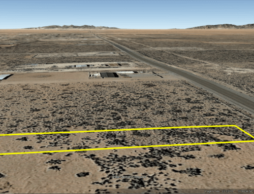
Acres: 10
Property Id: 14588
Legal Description: AB 5224, SOUTHWEST SUNSITES, UNIT 203, SECTION 22, BLOCK 63, PSL
Tract/Lot 67 5 Acres more or less
Tract/Lot 68 5 Acres more or less
Culberson CAD: https://culbersoncad.org/Home/Details?parcelId=14588&ownershipId=14399
Culberson CAD GIS Map: https://maps.pandai.com/CulbersonCAD/?find=14588
Recorded Deed: recorded purch deed 10 Acres Culberson 14588
Elevation: 3,826 ft.
Topography: Flat
Roads: Dirt
HOA/POA: none
Utilities: none
This is off-grid land. There are no city utilities here. You can use batteries, a generator, solar panels or windmill for electricity.
For water you can bring it with you, drill a well, have water trucked in and delivered, set up a rain catchment system
Mineral Classified Lands: according to the Texas General Land office map, this property is “mineral classified land” which means that the State of Texas owns the mineral rights and splits them 50/50 with the current surface owner.
State: Texas
County: Culberson
Property Tax: $72.88 yr.
Nearest Town: Van Horn, TX
Have Questions? – Read our F.A.Q.s or send us a message or see our testimonials.
Google Map Link: https://maps.app.goo.gl/nc3LCZXzygj9Eqyg6
A phone app such as Land Glide or OnX Hunt can be used to find parcel lines and corners while walking the property (if using OnX Hunt be sure to add the “TX Private Lands” map layer to see the parcel lines).
GPS Coordinates:
NorthWest Corner: 31° 4’19.13″N,104°38’47.14″W
SouthWest Corner: 31° 4’12.87″N,104°38’47.18″W
SouthEast Corner: 31° 4’12.84″N,104°38’39.45″W
NorthEast Corner: 31° 4’19.18″N,104°38’39.30″W
Links with information on Van Horn:
Area Attractions:
Guadalupe Mountains National Park
Ready to make this property yours? Have questions? Contact us today to start your journey to land ownership in beautiful West Texas!
CONTACT US
Have Questions? Click Here To Send Us a Message!

Click Here To See Our Customer Testimonials
Click Here To See Our Frequently Asked questions
Who do you know, that’s as awesome as you, that is looking for affordable land?
Share this opportunity with them!
Together, we can make land ownership dreams come true. Thank you! 🌲
![]()