Cash Price: $14,700
Owner Finance: $15,750 – $300 doc fee/$0 down & 90 payments of $187.75 ($175 Loan Payment, $10.00 Service Fee, $2.75 property tax)
• No credit check
• No interest
• No prepayment penalties
Click Here To Pay My $300 Doc Fee
Note: Doc Fee can be paid using credit or debit card. Monthly payments must be paid using ACH – checking account/routing number.
⚠️ Important: While you can camp and enjoy your property while making payments, permanent residency is not permitted until the land is fully paid off. Weekend camping and recreational use are welcome!
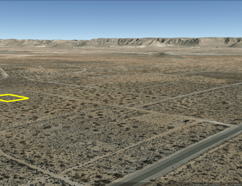
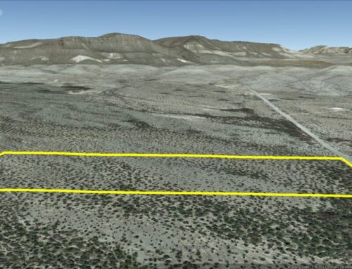
Acres: 10
Property Id: 31434
Legal Description: SW4 of the NE4 of the SW4 of Section 1, BLOCK G-12, G.C. & S.F. Ry. Co. Survey, +/-10 Acres. No mineral rights shall be conveyed with this land. There shall be established a 20 foot easement along the north, south, east and west boundaries of the above said parcel for access purposes.
Brewster CAD: https://esearch.brewstercotad.org/Property/View/31434
Brewster CAD GIS Map: https://gis.bisclient.com/brewstercad/index.html?find=31434
Recorded Deed: recorded purch deed 10 Acres Brewster 31434
Elevation: 3,283
Topography: Sloped
Roads: Dirt Road
Utilities: Off-Grid – This is off-grid land. There are no city utilities here. You can use batteries, a generator, solar panels or windmill for electricity.
For access to water, you can bring it with you, drill a well, have water trucked in and delivered, or set up a rain catchment system.
State: Texas
County: Brewster
Property Tax: $32.99 yr
HOA/POA: NONE – this property is not part of any POA
Nearest Town: Alpine, TX
Have Questions? – Read our F.A.Q.s or send us a message or see our testimonials.
Google Map Link: https://maps.app.goo.gl/Lzs1jPax9GEvzt1E6
A phone app such as Land Glide or OnX Hunt can be used to find parcel lines and corners while walking the property (if using OnX Hunt be sure to add the “TX Private Lands” map layer to see the parcel lines).
GPS Coordinates:
NW: 29.440777°,-103.682108°
SW: 29.439124°,-103.682084°
SE: 29.439165°,-103.680092°
NE: 29.441004°,-103.680111°
Big Bend area attractions – www.ghosttowntexas.com/bigbend.html
Terlingua Ranch – terlinguaranch.com/
Big Bend National Park – www.nps.gov/bibe/index.htm
Big Bend Ranch State Park – tpwd.texas.gov/state-parks/big-bend-ranch
Walmart: 2 hours to Fort Stockton
Travel Time by Car
Odessa: 3h 16m
San Angelo: 4h 3m
Carlsbad, NM: 4h 10m
El Paso: 4h 23m
Las Cruces, NM : 5h 7m
Lubbock: 5h 23m
Abilene:5h 41m
San Antonio: 6h 24m
Amarillo: 7h 7m
Killeen:7h 7m
Laredo:7h 13m
Fort Worth:7h 47m
Corpus Christie:8h 22m
Houston:9h 8m
Brownsville:10h 20m
Big Game
Mule Deer
White-tailed Deer
Pronghorn
Desert Bighorn Sheep
Javelina
Ready to make this property yours? Have questions? Contact us today to start your journey to land ownership in beautiful West Texas!
CONTACT US
Have Questions? Click Here To Send Us a Message!

Click Here To See Our Customer Testimonials
Click Here To See Our Frequently Asked questions
Who do you know, that’s as awesome as you, that is looking for affordable land?
Share this opportunity with them!
Together, we can make land ownership dreams come true. Thank you! 🌲
![]()