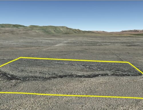
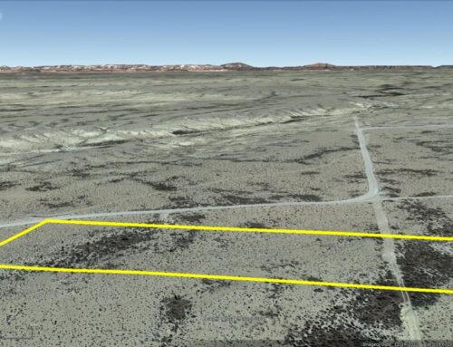
Huge 5 acre parcel in East El Paso County only 1.12 miles south of Montana Avenue.
Cash Price: $33,000
Owner Finance: $34,400 – $300 doc fee/$200 down & 114 payments of $312.74 ($300 Loan Payment, $10.00 Service Fee, $2.74 property tax)
• No credit check
• No interest
• No prepayment penalties
Click Here To Pay Your $500 Doc Fee & Down Payment
Note: Doc Fee can be paid using credit or debit card. Monthly payments must be paid using ACH – checking account/routing number.
⚠️ Important: While you can camp and enjoy your property while making payments, permanent residency is not permitted until the land is fully paid off. Weekend camping and recreational use are welcome!
Acres: 5
Property Id: 177981
Legal Description: The West Half of the Northwest Quarter of the Southeast Quarter of the Southwest Quarter of Section 6, Block 7, PUBLIC SCHOOL LANDS, El Paso County, Texas, being five acres, more or less; RESERVING, HOWEVER, an appurtenant easement over the North, East, South and West 20 feet of said property, unto GRANTOR and all persons claiming under it, and unto the general public for road purposes, and reserving said easement unto GRANTOR and all persons claiming under it, for the placement, maintenance and operation of public utilities.
El Paso CAD: https://epcad.org/Search/Details/177981/2025
(CAD site can take up to six months to update after ownership is transferred by recorded deed at county clerk’s office.)
El Paso CAD GIS Map: https://go.epcad.org/gis?find=X60700000601140
El Paso County Tax Assessor: https://actweb.acttax.com/act_webdev/elpaso/showdetail2.jsp?can=X60700000601140
Recorded Deed: recorded purchase deed 5 Acres El Paso 177981
Elevation: 4,177 ft.
Topography: Flat
Roads: Dirt
HOA/POA: None
Utilities: None
This is off-grid land. There are no city utilities here. You can use batteries, a generator, solar panels or windmill for electricity.
For water you can bring it with you, drill a well, have water trucked in and delivered, set up a rain catchment system
Mineral Classified Lands: according to the Texas General Land office map, this property is “mineral classified land” which means that the State of Texas owns the mineral rights and splits them 50/50 with the current surface owner.
State: Texas
County: El Paso
Property Tax: $32.88 yr
Nearest Town: El Paso, TX
Have Questions? – Read our F.A.Q.s or send us a message or see our testimonials.
Google Map Link: https://maps.app.goo.gl/omKWoTVZqyCZnAr28
A phone app such as Land Glide or OnX Hunt can be used to find parcel lines and corners while walking the property (if using OnX Hunt be sure to add the “TX Private Lands” map layer to see the parcel lines).
GPS Coordinates:
NorthWest Corner: 31.815886°,-106.093932°
SouthWest Corner: 31.814099°,-106.093908°
SouthEast Corner: 31.814095°,-106.092848°
NorthEast Corner: 31.815888°,-106.092867°
Area Attractions:
Franklin Mountains State Park-El Paso
Hueco Tanks State Historic Site-El Paso
Ready to make this property yours? Have questions? Contact us today to start your journey to land ownership in beautiful West Texas!
CONTACT US
Have Questions? Click Here To Send Us a Message!

Click Here To See Our Customer Testimonials
Click Here To See Our Frequently Asked questions
Who do you know, that’s as awesome as you, that is looking for affordable land?
Share this opportunity with them!
Together, we can make land ownership dreams come true. Thank you! 🌲
![]()